PLANTS | ANIMALS | ECOLOGY | FUNGI | GEOLOGY | GARDENING | TOOLS
MEXICAN PLANTS & ANIMALS HOME

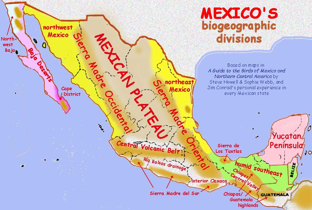
BAJA DESERTS: Mostly rugged desert. Along the coasts a few bays and estuaries, mangroves in the south.
CAPE DISTRICT (Baja): Sierra de San Lázaro peaks at 6857ft (2090m), with desert deciduous scrub on the lower slopes transitioning to oak/pine on the upper. The peninsula's southern tip is great for spotting migrating and seldom-appearing bird species.
CENTRAL VOLCANIC BELT: Volcanic peaks of Orizaba and the Volcanes de Colima rise as forested islands above the surrounding agricultural land. Lower down, oaks transition up into oak/pine, then pine, with firs on the cooler, wetter slopes. The highest peaks are rocky and bare, or perpetually covered with snow. Here and there are scattered lakes and marshes. Orizaba rises to 18,855ft (5747m).
CHIAPAS CENTRAL VALLEY: Originally tropical deciduous forest and scrub covered the Central Valley's floor, but now over most of the area irrigated farmland has taken its place. Some semideciduous woodland occurs in the highland foothills.
CHIAPAS/ GUATEMALA HIGHLANDS: Mostly the highlands have been cleared for ranching and farming. On steeper, higher slopes in secluded areas there are patches of oak/pine forest and maybe some cloud forest. Volcán Tacaná on the Guatemalan border rises to 13,428ft(4093m)
HUMID SOUTHEAST: Now the great forests of the lowland humid southeast have practically disappeared, converted to ranches, plantations and the like. In southern Veracruz and western Tabasco states there are extensive freshwater marshes and lagoons. Sometimes patches of natural grassy savannas occur.
INTERIOR OAXACA: Higher in elevation and thus cooler than the adjacent Río Balsas Drainage, so instead of thorn forest the natural vegetation mostly is subtropical and temperate scrub.
MEXICAN PLATEAU: Arid, rolling, grassy/scrubby plains rise gradually from about 1600-3300 ft(500-1000m) in the north to about 5000-6500ft (1500-2000m) in the south. Ranching and agriculture has profoundly transformed most of the area, though on upper slopes arid oak and oak/pine woodlands appear.
NORTHWEST BAJA: Desert/chaparral in the lowlands changing to oak higher up, and conifer forests at higher elevations. El Picacho del Diablo in the Sierra San Pedro Mártir range rises to 10,154ft (3095m)
NORTHEAST MEXICO: Along the coast there are mangrove-fringed lagoons and barrier beaches. Inland, desert in the north with rocky barrens, grasslands and scrub, often mesquite, potentially giving way farther south to deciduous woodland, then semideciduous forest. However, the less arid it becomes, the more ranching and farming there is, with only small patches of forest being left in the central and southern zones, mostly along rivers. Some pieces of thorn forest, mostly in the Sierra Madre foothills and highlands, on steep limestone ridges.
NORTHWEST MEXICO: Sonora Desert (Desierto de Altar with sand dunes) in the north becoming less arid southward. Moving inland from the coasts, desert gives way to deciduous thorn scrub and woodland. Fingers of tropical forest along river valleys in the southern part. Some mangroves and lagoons along the coast in the south.
RÍO BALSAS DRAINAGE: This very hot, arid lowland along the Río Balsas originally was largely thorn forest but now is much disrupted by ranching and agriculture. During past glacial periods, because of its hot climate, it was a refuge for many species, and now is known as having the richest collection of endemic birds in northern Middle America.
SIERRA DE LOS TUXTLAS: This highland rises from close to sea level to 5577ft (1700m), noteworthy as the northernmost outpost of tropical humid evergreen forest, and because of its isolation from other highlands hosting several endemic species.
SIERRA MADRE DEL SUR: These highlands are hot and arid below, with middle elevations sometimes covered with humid evergreen forest trending toward cloud forest.
SIERRA MADRE OCCIDENTAL: Rising in elevation, thorn forest gives way to tropical semideciduous forest and eventually oak scrub, pine-oak, and pine at hi gher elevations. Geology here is mainly volcanic, in contrast to the limestone Sierra Madre Oriental.
SIERRA MADRE ORIENTAL: These mountains are made of limestone with underground drainage, contrasting to the Sierra Madre Occidental's volcanic origin. In the more arid north, desert vegetation down below gives way to chaparral, then oaks, oak/pine, and on the highest, moistest peaks, fir. In the south, facing the Gulf of Mexico, the highest peaks may bear remnants of cloud forest, or maybe by now they're all destroyed.
YUCATAN PENINSULA: See our special Vegetation of the Yucatan page.
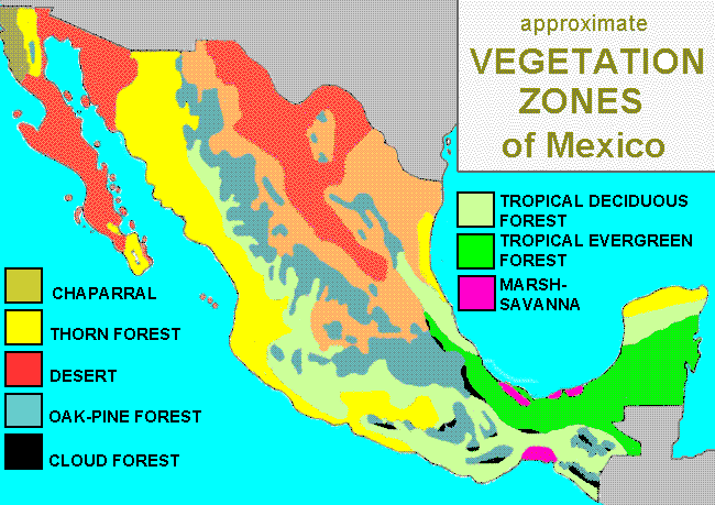
GENERAL VEGETATION MAP:
All of Mexico except for the most isolated desert regions has been profoundly altered by ranching, grazing, farming, firewood gathering, deforestation, rare-plant robbery (especially cacti, palms, orchids & bromeliads) etc. Most affected have been the Oak-Pine and Tropical Evergreen and Deciduous Forest zones. This map more shows what used to be, or what exists in small patches only, except for the most arid, not irrigated places.